Checking for non-preferred file/folder path names (may take a long time depending on the number of files/folders) ...
This resource contains some files/folders that have non-preferred characters in their name. Show non-conforming files/folders.
This resource contains content types with files that need to be updated to match with metadata changes. Show content type files that need updating.
SSHCZO -- Meteorology, Air Temperature, Precipitation, Soil Moisture, Solar Radiation -- Shale Transect -- (2010-2014)
| Authors: |
|
|
|---|---|---|
| Owners: |
|
This resource does not have an owner who is an active HydroShare user. Contact CUAHSI (help@cuahsi.org) for information on this resource. |
| Type: | Resource | |
| Storage: | The size of this resource is 20.6 MB | |
| Created: | Nov 19, 2019 at 3:05 a.m. (UTC) | |
| Last updated: | Nov 26, 2019 at 7:59 p.m. (UTC) | |
| Citation: | See how to cite this resource | |
| Content types: | Single File Content |
| Sharing Status: | Public |
|---|---|
| Views: | 2902 |
| Downloads: | 379 |
| +1 Votes: | Be the first one to this. |
| Comments: | No comments (yet) |
Abstract
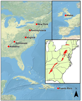
Weather stations deployed across the CZO Shale Transect, including sites in New York, Virginia, Tennessee, Alabama and Puerto Rico, provide continuous measurements of climatic conditions influencing shale weathering. Measurements are recorded every two hours and include precipitation, air temperature, relative humidity, solar radiation, wind speed, soil temperature, soil moisture and soil electrical conductivity. Data output from each weather station will help researchers understand the effects of climate on shale weathering and soil processes in various climates.
Subject Keywords
Coverage
Spatial
Temporal
| Start Date: | |
|---|---|
| End Date: |
Content
ReadMe.md
SSHCZO -- Meteorology, Air Temperature, Precipitation, Soil Moisture, Solar Radiation -- Shale Transect -- (2010-2014)
OVERVIEW
Description/Abstract
Weather stations deployed across the CZO Shale Transect, including sites in New York, Virginia, Tennessee, Alabama and Puerto Rico, provide continuous measurements of climatic conditions influencing shale weathering. Measurements are recorded every two hours and include precipitation, air temperature, relative humidity, solar radiation, wind speed, soil temperature, soil moisture and soil electrical conductivity. Data output from each weather station will help researchers understand the effects of climate on shale weathering and soil processes in various climates.
Creator/Author
Dere, Ashlee|White, Tim
CZOs
Shale Hills
Contact
Dr. Ashlee Dere, The Pennsylvania State University, 315 Hosler Building, University Park, PA 16802, 858.243.2644, ald271@psu.edu
Subtitle
Level 0 Raw Data - Non-streaming
SUBJECTS
Disciplines
Climatology / Meteorology|Hydrology
Topics
Meteorology|Air Temperature|Precipitation|Soil Moisture|Solar Radiation
Keywords
shale|soil|temperature|moisture|relative humidity|precipitation|wind speed|solar radiation|electrical conductivity
Variables
Timestamp|Record|Battery voltage (V)|Relative Humidity (%)|Air Temperature (deg C)|Wind Speed (m/s)|Average Wind Speed (m/s)|Precipitation (mm)|Total Precipitation (mm)|Solar Radiation (W/m2)|Volumetric Water Content (dielectric*50)|Electrical Conductivity (dS/m)|Ground Temperature (deg C)
Variables ODM2
Temperature|Wind speed|Battery voltage|Electrical conductivity|Precipitation|Recorder code|Relative humidity|Radiation, net|Volumetric water content
TEMPORAL
Date Start
2010-06-25
Date End
2014-05-30
SPATIAL
Field Areas
Shale Transect
Location
Shale Transect
North latitude
43.02898333
South latitude
18.30083333
West longitude
-85.79333333
East longitude
-65.09331667

REFERENCE
Citation
The following acknowledgment should accompany any publication or citation of these data: Logistical support and/or data were provided by the NSF-supported Shale Hills Susquehanna Critical Zone Observatory.
CZO ID
2692
COMMENTS
Comments
Wind speed measured with a Secondwind 3C Anemometer, http://www.secondwind.com. Precipitation measured with a Texas Electronics Rain Gage (TE525-ET), http://www.campbellsci.com. Air temperature measured with a Campbell Scientific HMP45C Temperature and Relative Humidity Probe, http://www.campbellsci.com. Relative humidity measured with a Campbell Scientific HMP45C Temperature and Relative Humidity Probe, http://www.campbellsci.com. Solar radiation measured with a Davis Instruments Vantage Pro2 Solar Radiation Sensor, http://www.davis.com. Soil moisture, electrical conductivity and temperature measured with a Decagon 5TE Sensor, http://www.decagon.com. See color coded key in each data file for known problems concerning data quality. Volumetric Water Content (VWC) data require transformation of output units (dielectric50) using the following equation (http://www.decagon.com/assets/Uploads/13392-03-AN-Calibration-Equations-for-the-ECH2O-EC-5-ECH2o-TE-and-5TE-Sensors.pdf ): θ (m3/m3) = 3.44x10^-11 * Serial^3 – 2.20x10^-7 Serial^2 + 5.84x10^-4 * Serial – 5.3x10^-2
Additional Metadata
| Name | Value |
|---|---|
| czos | Shale Hills |
| czo_id | 2692 |
| citation | The following acknowledgment should accompany any publication or citation of these data: Logistical support and/or data were provided by the NSF-supported Shale Hills Susquehanna Critical Zone Observatory. |
| comments | Wind speed measured with a Secondwind 3C Anemometer, http://www.secondwind.com. Precipitation measured with a Texas Electronics Rain Gage (TE525-ET), http://www.campbellsci.com. Air temperature measured with a Campbell Scientific HMP45C Temperature and Relative Humidity Probe, http://www.campbellsci.com. Relative humidity measured with a Campbell Scientific HMP45C Temperature and Relative Humidity Probe, http://www.campbellsci.com. Solar radiation measured with a Davis Instruments Vantage Pro2 Solar Radiation Sensor, http://www.davis.com. Soil moisture, electrical conductivity and temperature measured with a Decagon 5TE Sensor, http://www.decagon.com. See color coded key in each data file for known problems concerning data quality. Volumetric Water Content (VWC) data require transformation of output units (dielectric*50) using the following equation (http://www.decagon.com/assets/Uploads/13392-03-AN-Calibration-Equations-for-the-ECH2O-EC-5-ECH2o-TE-and-5TE-Sensors.pdf ): θ (m3/m3) = 3.44x10^-11 * Serial^3 – 2.20x10^-7 *Serial^2 + 5.84x10^-4 * Serial – 5.3x10^-2 |
| keywords | shale, soil, temperature, moisture, relative humidity, precipitation, wind speed, solar radiation, electrical conductivity |
| subtitle | Level 0 Raw Data - Non-streaming |
| variables | Timestamp, Record, Battery voltage (V), Relative Humidity (%), Air Temperature (deg C), Wind Speed (m/s), Average Wind Speed (m/s), Precipitation (mm), Total Precipitation (mm), Solar Radiation (W/m2), Volumetric Water Content (dielectric*50), Electrical Conductivity (dS/m), Ground Temperature (deg C) |
| disciplines | Climatology / Meteorology, Hydrology |
How to Cite
This resource is shared under the Creative Commons Attribution CC BY.
http://creativecommons.org/licenses/by/4.0/

Comments
There are currently no comments
New Comment