Checking for non-preferred file/folder path names (may take a long time depending on the number of files/folders) ...
This resource contains some files/folders that have non-preferred characters in their name. Show non-conforming files/folders.
This resource contains content types with files that need to be updated to match with metadata changes. Show content type files that need updating.
SSCZO -- Soil Moisture, Soil Temperature, Electrical Conductivity -- Critical Zone Tree 1 -- (2008-2016)
| Authors: |
|
|
|---|---|---|
| Owners: |
|
This resource does not have an owner who is an active HydroShare user. Contact CUAHSI (help@cuahsi.org) for information on this resource. |
| Type: | Resource | |
| Storage: | The size of this resource is 2.6 MB | |
| Created: | Nov 19, 2019 at 2:19 a.m. (UTC) | |
| Last updated: | Nov 26, 2019 at 7:59 p.m. (UTC) | |
| Citation: | See how to cite this resource | |
| Content types: | Single File Content |
| Sharing Status: | Public |
|---|---|
| Views: | 3753 |
| Downloads: | 601 |
| +1 Votes: | Be the first one to this. |
| Comments: | No comments (yet) |
Abstract
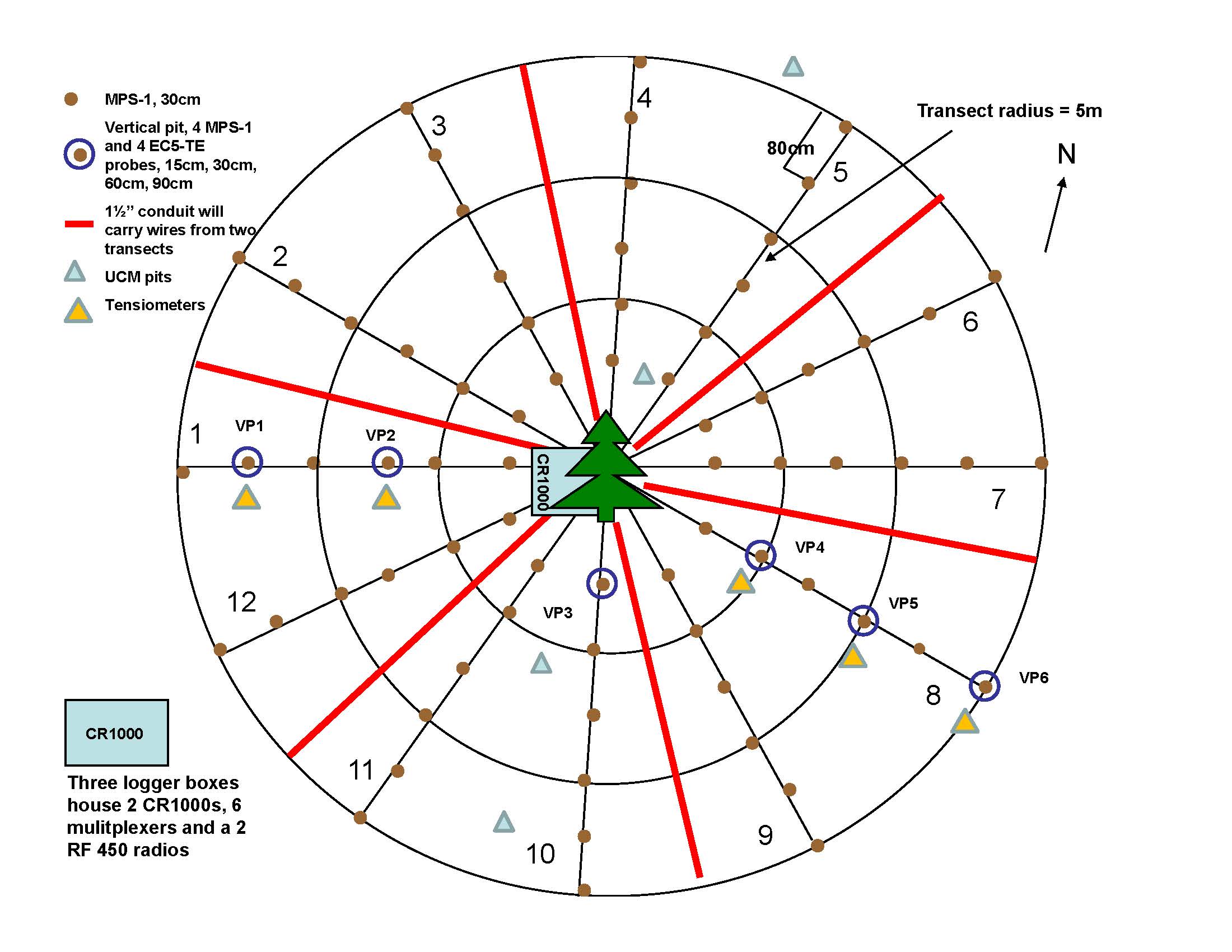
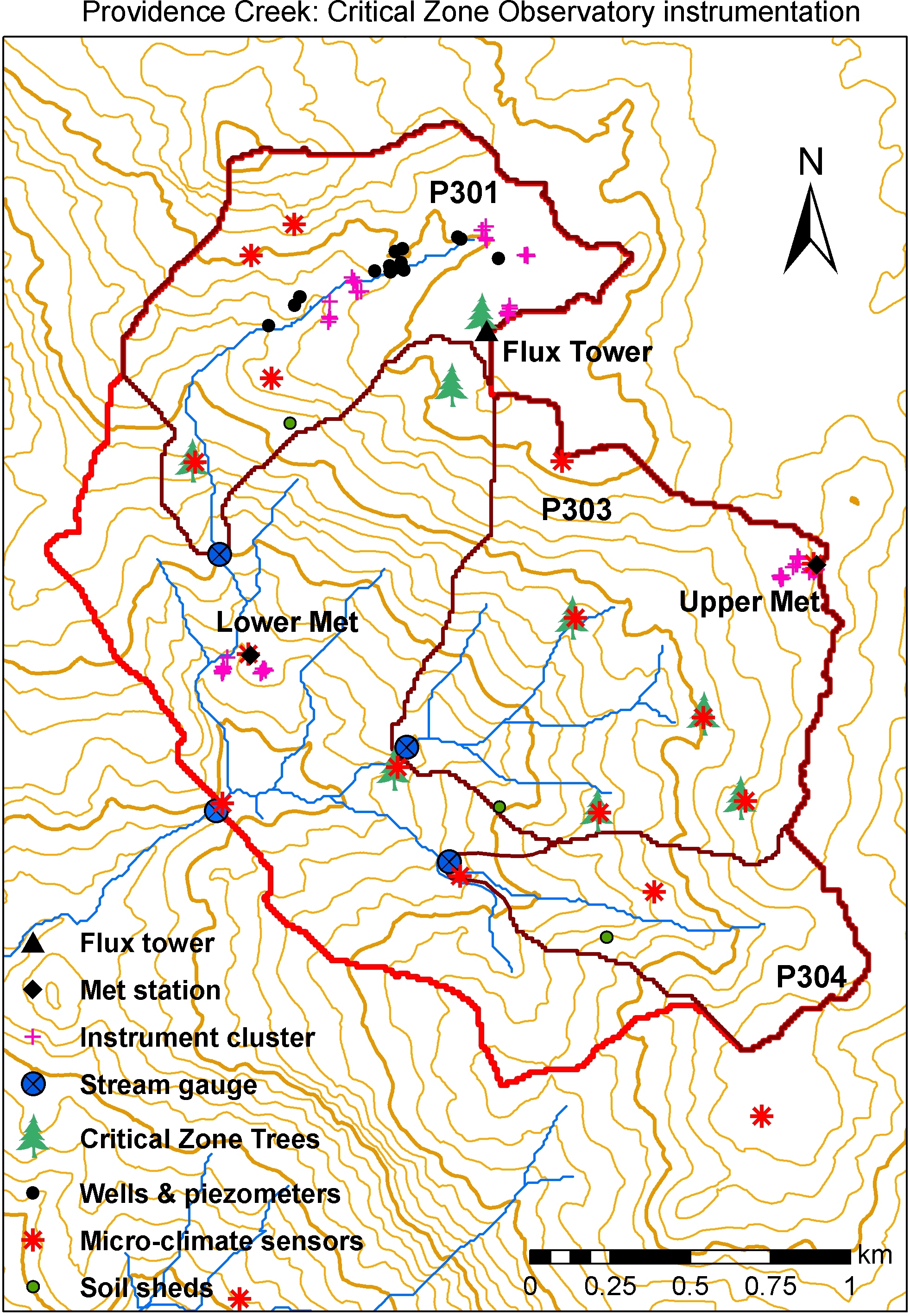
An array of sensors distributed around Critical Zone Tree-1 provides highly detailed data on the water balance of a single white fir (Abies concolor) tree. Data are logged on a refined spatial and temporal scale. See the map tab for more information on the sensor and soil pit locations. Soil volumetric water content (VWC) temperature, and electrical conductivity measured using http://www.decagon.com/soil-moisture-sensors/ Decagon Devices 5-TE sensor at depths of 10, 30, 60, and 90 cm below the mineral soil surface in 6 soil pits. Pits range from 1-5 m from CZT-1.
Additional metadata information is available for the https://eng.ucmerced.edu/snsjho/files/MHWG/Field/Southern_Sierra_CZO_KREW/Critical_Zone_Tree/CZTree1/Level_1b/CZT1_site.txt site and https://eng.ucmerced.edu/snsjho/files/MHWG/Field/Southern_Sierra_CZO_KREW/Critical_Zone_Tree/CZTree1/Level_1b/CZT1_methods.txt methods .
Additional metadata are available in the https://eng.ucmerced.edu/snsjho/files/MHWG/Field/Southern_Sierra_CZO_KREW/Critical_Zone_Tree/CZTree1/Level_1b parent directory of this dataset, such as site properties, instrumentation, and processing notes.
Date Range Comments: hourly
Subject Keywords
Coverage
Spatial
Temporal
| Start Date: | |
|---|---|
| End Date: |
Content
ReadMe.md
SSCZO -- Soil Moisture, Soil Temperature, Electrical Conductivity -- Critical Zone Tree 1 -- (2008-2016)
OVERVIEW
Description/Abstract
An array of sensors distributed around Critical Zone Tree-1 provides highly detailed data on the water balance of a single white fir (Abies concolor) tree. Data are logged on a refined spatial and temporal scale. See the map tab for more information on the sensor and soil pit locations. Soil volumetric water content (VWC) temperature, and electrical conductivity measured using http://www.decagon.com/soil-moisture-sensors/ Decagon Devices 5-TE sensor at depths of 10, 30, 60, and 90 cm below the mineral soil surface in 6 soil pits. Pits range from 1-5 m from CZT-1.
Additional metadata information is available for the https://eng.ucmerced.edu/snsjho/files/MHWG/Field/Southern_Sierra_CZO_KREW/Critical_Zone_Tree/CZTree1/Level_1b/CZT1_site.txt site and https://eng.ucmerced.edu/snsjho/files/MHWG/Field/Southern_Sierra_CZO_KREW/Critical_Zone_Tree/CZTree1/Level_1b/CZT1_methods.txt methods .
Additional metadata are available in the https://eng.ucmerced.edu/snsjho/files/MHWG/Field/Southern_Sierra_CZO_KREW/Critical_Zone_Tree/CZTree1/Level_1b parent directory of this dataset, such as site properties, instrumentation, and processing notes.
Creator/Author
Peter Hartsough|Jan Hopmans
CZOs
Sierra
Contact
phartsough@ucdavis; Data Manager: xmeng@ucmerced.edu
Subtitle
Measured at depths of 10, 30, 60, and 90 cm below the mineral soil surface
SUBJECTS
Disciplines
Hydrology
Topics
Soil Moisture|Soil Temperature|Electrical Conductivity
Keywords
Water balance|critical zone tree|CZT|white fir|mid-elevation|Davis|hydrology|volumetric water content|VWC|EC
Variables
Volumetric Water Content|Temperature|Electrical Conductivity|
Variables ODM2
Bulk electrical conductivity|Temperature|Volumetric water content
TEMPORAL
Date Start
2008-08-21
Date End
2016-10-01
Date Range Comments
hourly
SPATIAL
Field Areas
nan
Location
Critical Zone Tree 1
North latitude
37.068032
South latitude
37.068032
West longitude
-119.19440700000001
East longitude
-119.19440700000001


REFERENCE
CZO ID
2637
Additional Metadata
| Name | Value |
|---|---|
| czos | Sierra |
| czo_id | 2637 |
| keywords | Water balance, critical zone tree, CZT, white fir, mid-elevation, Davis, hydrology, volumetric water content, VWC, EC |
| subtitle | Measured at depths of 10, 30, 60, and 90 cm below the mineral soil surface |
| variables | Volumetric Water Content, Temperature, Electrical Conductivity, |
| disciplines | Hydrology |
| date_range_comments | hourly |
How to Cite
This resource is shared under the Creative Commons Attribution CC BY.
http://creativecommons.org/licenses/by/4.0/

Comments
There are currently no comments
New Comment