Checking for non-preferred file/folder path names (may take a long time depending on the number of files/folders) ...
This resource contains some files/folders that have non-preferred characters in their name. Show non-conforming files/folders.
This resource contains content types with files that need to be updated to match with metadata changes. Show content type files that need updating.
| Authors: |
|
|
|---|---|---|
| Owners: |
|
This resource does not have an owner who is an active HydroShare user. Contact CUAHSI (help@cuahsi.org) for information on this resource. |
| Type: | Resource | |
| Storage: | The size of this resource is 14 bytes | |
| Created: | May 20, 2025 at 4:42 a.m. (UTC) | |
| Last updated: | Feb 04, 2026 at 9:40 p.m. (UTC) | |
| Citation: | See how to cite this resource |
| Sharing Status: | Public |
|---|---|
| Views: | 1191 |
| Downloads: | 46 |
| +1 Votes: | Be the first one to this. |
| Comments: | No comments (yet) |
Abstract
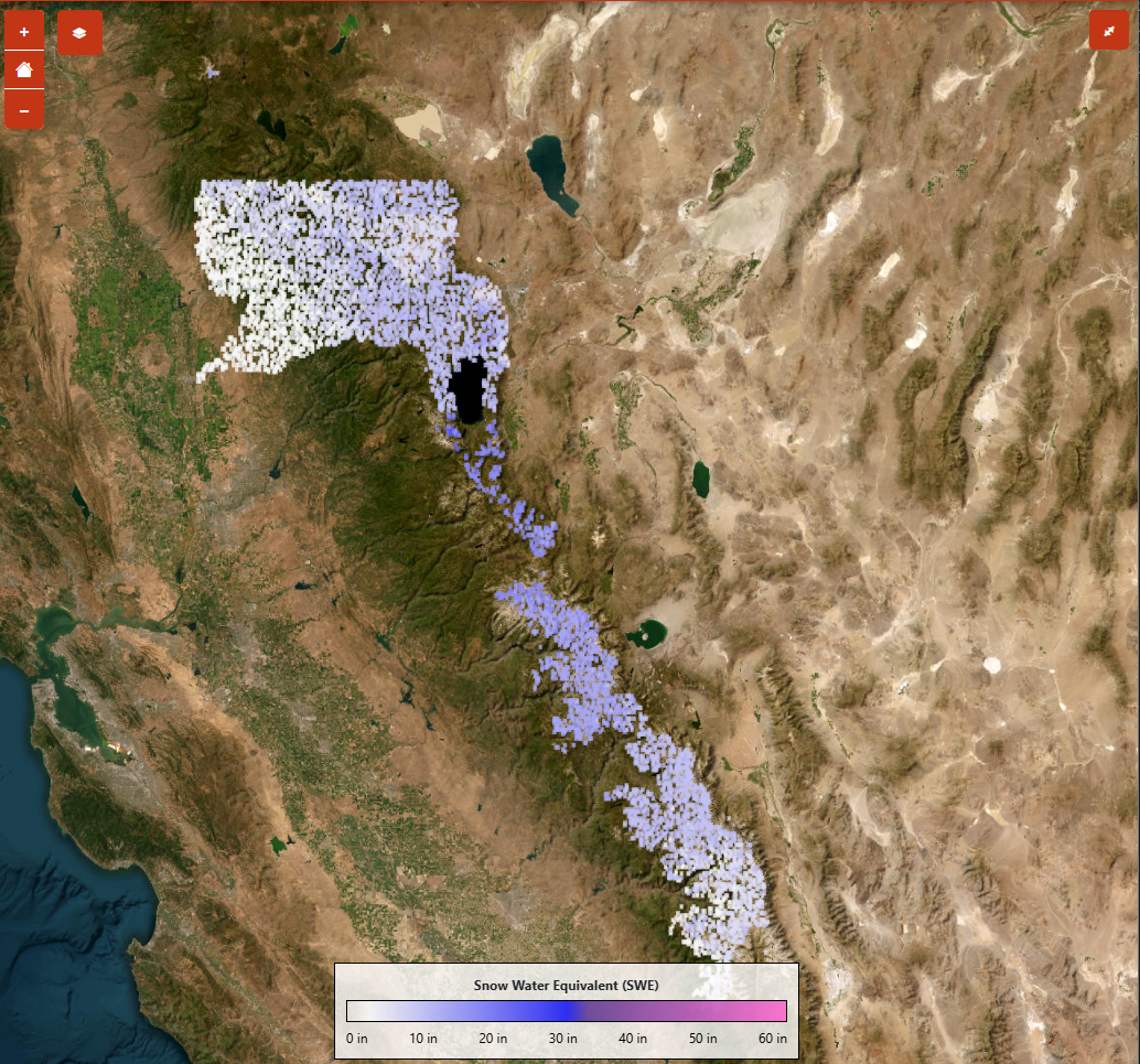
The current iteration of the SWEML produces 11,000 1 km SWE inferences for select locations throughout the Western U.S. plus the Upper Colorado River Basin. There is a heavy focus on SWE inferences in the Sierra Nevada mountains, Colorado Rockies, and Wind River Range in Wyoming. The NSM pipeline assimilates nearly 700 snow telemetry (SNOTEL) and California Data Exchange Center (CDEC) sites and combines them with processed lidar-derived terrain features for the prediction of a 1 km x 1 km SWE inference in critical snowsheds. The ML pipeline retrieves all SWE observations from SNOTEL and CDEC snow monitoring locations for the date of interest and processes the SWE observations into a model-friendly data frame alongside lidar-derived terrain features, seasonality metrics, previous SWE estimates, and location. SWEML predicts SWE using a uniquely trained multilayered perceptron network model for each region and supports an interactive visualization of the SWE estimates across the western U.S.
Subject Keywords
Coverage
Temporal
| Start Date: | |
|---|---|
| End Date: |
Content
Additional Metadata
| Name | Value |
|---|---|
| page_url | https://tethys.ciroh.org/apps/sweml/ |
| thumbnail_url | https://ciroh-portal-static-data.s3.us-east-1.amazonaws.com/c7616d61-046e-4a05-85d5-8e3312b18288.png |
How to Cite
This resource is shared under the Creative Commons Attribution CC BY.
http://creativecommons.org/licenses/by/4.0/
Comments
There are currently no comments
New Comment