Checking for non-preferred file/folder path names (may take a long time depending on the number of files/folders) ...
This resource contains some files/folders that have non-preferred characters in their name. Show non-conforming files/folders.
This resource contains content types with files that need to be updated to match with metadata changes. Show content type files that need updating.
| Authors: |
|
|
|---|---|---|
| Owners: |
|
This resource does not have an owner who is an active HydroShare user. Contact CUAHSI (help@cuahsi.org) for information on this resource. |
| Type: | Resource | |
| Storage: | The size of this resource is 5.9 MB | |
| Created: | Nov 19, 2019 at 2:37 a.m. (UTC) | |
| Last updated: | Nov 26, 2019 at 7:59 p.m. (UTC) | |
| Citation: | See how to cite this resource | |
| Content types: | Single File Content |
| Sharing Status: | Public |
|---|---|
| Views: | 3540 |
| Downloads: | 460 |
| +1 Votes: | Be the first one to this. |
| Comments: | No comments (yet) |
Abstract
Bull Creek Upper Met data collected by water year (previous October 01 through September 30 of named year). Standard meteorological data are being collected at the Bull Upper Meteorological site using a Campbell Scientific logger to control peripheral devices. The data are remotely downloaded via radio modem through the USFS radio network. A 15 watt solar panel provides power to continuously monitor temperature, relative humidity, wind speed, wind direction, radiation, snow depth, snow density and rainfall intensity at 15 minute intervals. Data processing compresses data to hourly intervals. The Bull Upper Met site is located at 2461 meters in elevation.
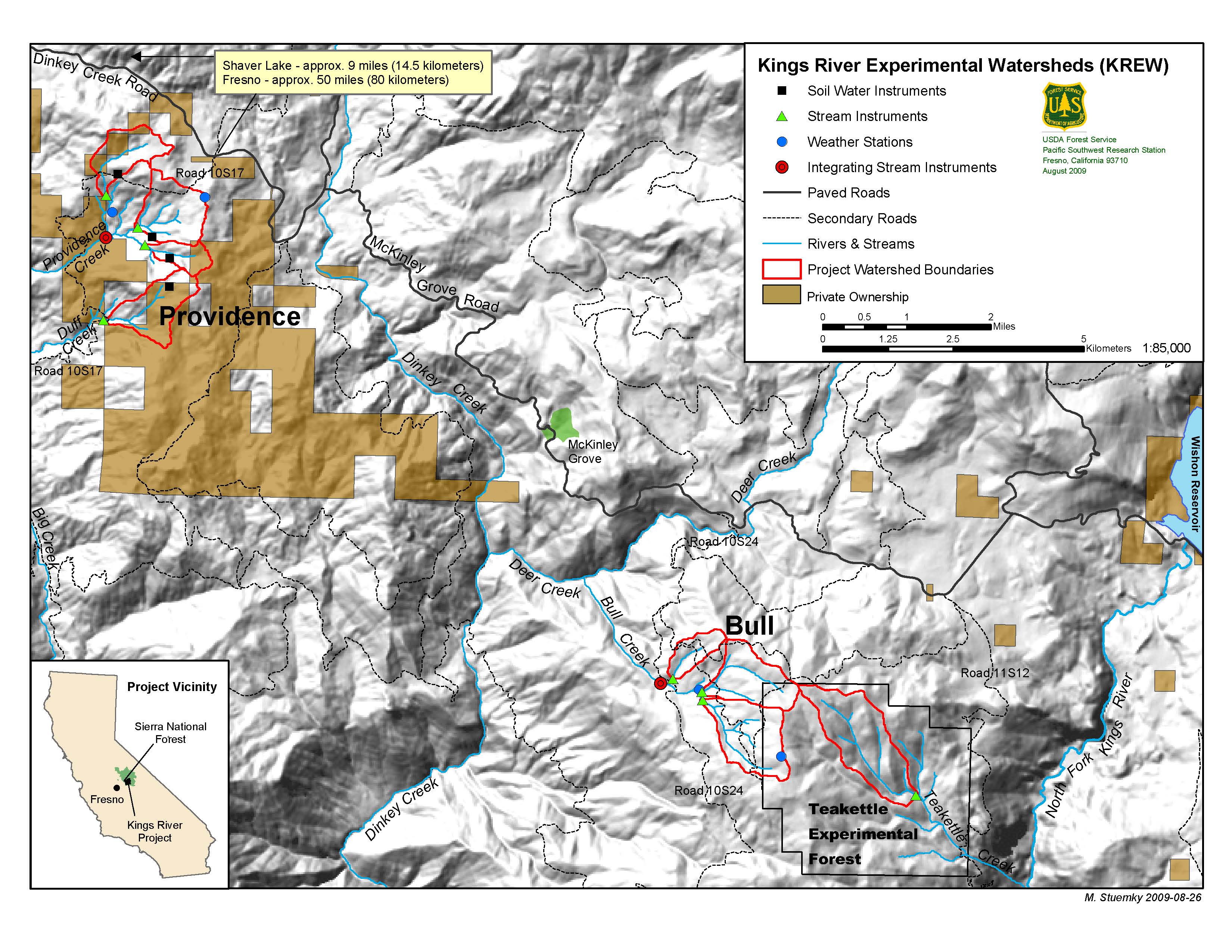
This met station is located at the Bull Creek site of the Kings River Experimental Watershed (KREW). Both the Providence and Bull Creek met stations were erected by the Forest Service Pacific Southwest research station as part of the KREW project using the same methods and sensors. Data processing was conducted by the CZO using the same programs. The Bull creek site acts as a nearby paired area, approximately 400 m higher in elevation than the Providence sites. See additional information on the https://eng.ucmerced.edu/snsjho/files/MHWG/Field/Southern_Sierra_CZO_KREW/Bull_Creek_Upper_Met/Meteorological_Station/Level_1b/UppBull_Met_Methods.txt methods, including sensors used, and https://eng.ucmerced.edu/snsjho/files/MHWG/Field/Southern_Sierra_CZO_KREW/Bull_Creek_Upper_Met/Meteorological_Station/Level_1b/UppBull_Met_Site.txt site .
Additional metadata are available in the https://eng.ucmerced.edu/snsjho/files/MHWG/Field/Southern_Sierra_CZO_KREW/Bull_Creek_Upper_Met/Meteorological_Station/Level_1b parent directory of this dataset, such as site properties, instrumentation, and processing notes.
Subject Keywords
Coverage
Spatial
Temporal
| Start Date: | |
|---|---|
| End Date: |
Content
ReadMe.md
SSCZO -- Meteorology -- Met Stations, KREW, Bull Creek, Upper -- (2003-2011)
OVERVIEW
Description/Abstract
Bull Creek Upper Met data collected by water year (previous October 01 through September 30 of named year). Standard meteorological data are being collected at the Bull Upper Meteorological site using a Campbell Scientific logger to control peripheral devices. The data are remotely downloaded via radio modem through the USFS radio network. A 15 watt solar panel provides power to continuously monitor temperature, relative humidity, wind speed, wind direction, radiation, snow depth, snow density and rainfall intensity at 15 minute intervals. Data processing compresses data to hourly intervals. The Bull Upper Met site is located at 2461 meters in elevation.
This met station is located at the Bull Creek site of the Kings River Experimental Watershed (KREW). Both the Providence and Bull Creek met stations were erected by the Forest Service Pacific Southwest research station as part of the KREW project using the same methods and sensors. Data processing was conducted by the CZO using the same programs. The Bull creek site acts as a nearby paired area, approximately 400 m higher in elevation than the Providence sites. See additional information on the https://eng.ucmerced.edu/snsjho/files/MHWG/Field/Southern_Sierra_CZO_KREW/Bull_Creek_Upper_Met/Meteorological_Station/Level_1b/UppBull_Met_Methods.txt methods, including sensors used, and https://eng.ucmerced.edu/snsjho/files/MHWG/Field/Southern_Sierra_CZO_KREW/Bull_Creek_Upper_Met/Meteorological_Station/Level_1b/UppBull_Met_Site.txt site .
Additional metadata are available in the https://eng.ucmerced.edu/snsjho/files/MHWG/Field/Southern_Sierra_CZO_KREW/Bull_Creek_Upper_Met/Meteorological_Station/Level_1b parent directory of this dataset, such as site properties, instrumentation, and processing notes.
Creator/Author
Carolyn Hunsaker
CZOs
Sierra
Contact
chunsaker@fs.fed.us; Data Manager: xmeng@ucmerced.edu
SUBJECTS
Disciplines
Climatology / Meteorology
Topics
Meteorology
Keywords
Temperature|Relative Humidity|Wind Speed|Wind Direction|Snow Depth|meteorology|Sierra National Forest|California|Pacific Southwest Research Station|PSW|Forest Service
Variables
Temperature|Relative Humidity|Wind Speed|Wind Direction|Snow Depth
Variables ODM2
Relative humidity|Snow depth|Temperature|Wind direction|Wind gust speed
TEMPORAL
Date Start
2003-10-01
Date End
2011-10-01
SPATIAL
Field Areas
Other instrumented sites
Location
Met Stations, KREW, Bull Creek, Upper
North latitude
36.9651656042559
South latitude
36.9651656042559
West longitude
-119.055633647798
East longitude
-119.055633647798

REFERENCE
CZO ID
2656
Related datasets
2529|2406|2643
COMMENTS
Comments
See https://eng.ucmerced.edu/snsjho/files/MHWG/Field/Southern_Sierra_CZO_KREW/Bull_Creek_Upper_Met/Meteorological_Station/Level_1b/WY_2011_upper_bull_process_note.txt process note from WY 2011 .
Additional Metadata
| Name | Value |
|---|---|
| czos | Sierra |
| czo_id | 2656 |
| comments | See https://eng.ucmerced.edu/snsjho/files/MHWG/Field/Southern_Sierra_CZO_KREW/Bull_Creek_Upper_Met/Meteorological_Station/Level_1b/WY_2011_upper_bull_process_note.txt process note from WY 2011 . |
| keywords | Temperature, Relative Humidity, Wind Speed, Wind Direction, Snow Depth, meteorology, Sierra National Forest, California, Pacific Southwest Research Station, PSW, Forest Service |
| variables | Temperature, Relative Humidity, Wind Speed, Wind Direction, Snow Depth |
| disciplines | Climatology / Meteorology |
| related_datasets | 2529, 2406, 2643 |
| related_datasets_hs | https://www.hydroshare.org/resource/0918a6975c864a398766d579e3687004/, https://www.hydroshare.org/resource/98574a24d4344b6bb99d12db5f1c4260/, https://www.hydroshare.org/resource/e7d4dcfc401b4a45a1d3c72e6056b103/ |
How to Cite
This resource is shared under the Creative Commons Attribution CC BY.
http://creativecommons.org/licenses/by/4.0/

Comments
There are currently no comments
New Comment