Checking for non-preferred file/folder path names (may take a long time depending on the number of files/folders) ...
This resource contains some files/folders that have non-preferred characters in their name. Show non-conforming files/folders.
This resource contains content types with files that need to be updated to match with metadata changes. Show content type files that need updating.
| Authors: |
|
|
|---|---|---|
| Owners: |
|
This resource does not have an owner who is an active HydroShare user. Contact CUAHSI (help@cuahsi.org) for information on this resource. |
| Type: | Resource | |
| Storage: | The size of this resource is 106.2 MB | |
| Created: | Nov 18, 2019 at 9:13 p.m. (UTC) | |
| Last updated: | Oct 23, 2020 at 3:19 a.m. (UTC) | |
| Citation: | See how to cite this resource | |
| Content types: | Single File Content |
| Sharing Status: | Public |
|---|---|
| Views: | 3665 |
| Downloads: | 293 |
| +1 Votes: | Be the first one to this. |
| Comments: | No comments (yet) |
Abstract
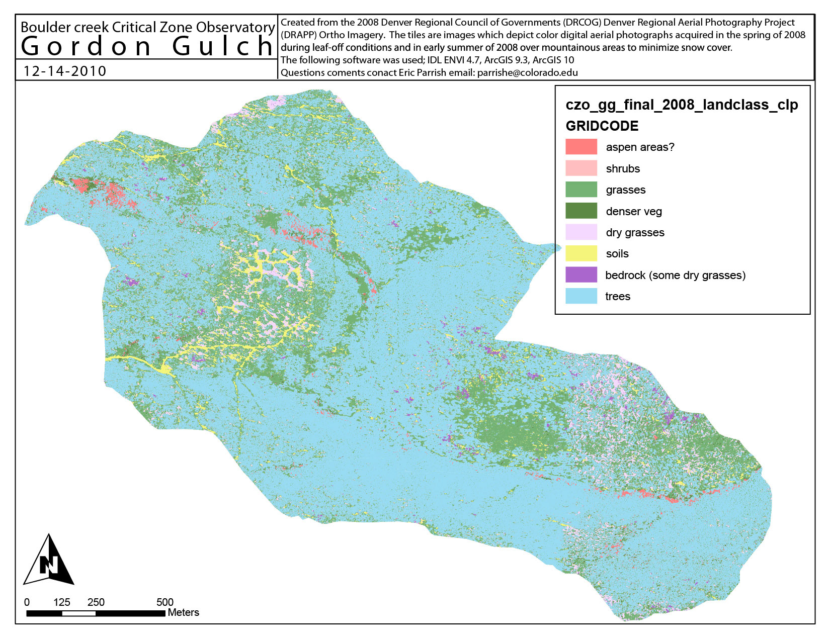
The Gordon Gulch site is in the mountane climatic zone. This site is divided into Lower and Upper Gordon Gulch. Lower Gordon Gulch is about 2.7473km2, with an average elevation of 2627m. Upper Gordon Gulch is about 1.0144km2, with an average elevation of 2680m.
This land classification of the Betasso site is created from the 2008 Denver Regional Council of Governments (DRCOG) Denver Regional Aerial Photography Project (DRAPP) Ortho imagery. The area is classified into 8 categories:
Subject Keywords
Coverage
Spatial
Temporal
| Start Date: | |
|---|---|
| End Date: |
Content
ReadMe.md
BCCZO -- Land Cover -- Gordon Gulch -- (2008)
OVERVIEW
Description/Abstract
The Gordon Gulch site is in the mountane climatic zone. This site is divided into Lower and Upper Gordon Gulch. Lower Gordon Gulch is about 2.7473km2, with an average elevation of 2627m. Upper Gordon Gulch is about 1.0144km2, with an average elevation of 2680m.
This land classification of the Betasso site is created from the 2008 Denver Regional Council of Governments (DRCOG) Denver Regional Aerial Photography Project (DRAPP) Ortho imagery. The area is classified into 8 categories:
Creator/Author
Eric Parrish
CZOs
Boulder
Contact
Eric.Parrish@colorado.edu
Subtitle
Land classification at Gordon Gulch
SUBJECTS
Disciplines
Biology / Ecology
Topics
Land Cover
Keywords
land classification|Gordon Gulch|land use
Variables
land classification
Variables ODM2
land classification
TEMPORAL
Date Start
2008-01-01
Date End
2008-12-31
SPATIAL
Field Areas
Gordon Gulch
Location
Gordon Gulch
North latitude
40.03496425945212
South latitude
39.98976244323424
West longitude
-105.4988302001812
East longitude
-105.44450921307009

REFERENCE
CZO ID
2460
Additional Metadata
| Name | Value |
|---|---|
| czos | Boulder |
| czo_id | 2460 |
| keywords | land classification, Gordon Gulch, land use |
| subtitle | Land classification at Gordon Gulch |
| variables | land classification |
| disciplines | Biology / Ecology |
How to Cite
This resource is shared under the Creative Commons Attribution CC BY.
http://creativecommons.org/licenses/by/4.0/

Comments
There are currently no comments
New Comment