Checking for non-preferred file/folder path names (may take a long time depending on the number of files/folders) ...
This resource contains some files/folders that have non-preferred characters in their name. Show non-conforming files/folders.
This resource contains content types with files that need to be updated to match with metadata changes. Show content type files that need updating.
| Authors: |
|
|
|---|---|---|
| Owners: |
|
This resource does not have an owner who is an active HydroShare user. Contact CUAHSI (help@cuahsi.org) for information on this resource. |
| Type: | Resource | |
| Storage: | The size of this resource is 163.8 KB | |
| Created: | Nov 19, 2019 at 12:10 a.m. (UTC) | |
| Last updated: | Nov 26, 2019 at 7:59 p.m. (UTC) | |
| Citation: | See how to cite this resource | |
| Content types: | Single File Content |
| Sharing Status: | Public |
|---|---|
| Views: | 3449 |
| Downloads: | 162 |
| +1 Votes: | Be the first one to this. |
| Comments: | No comments (yet) |
Abstract
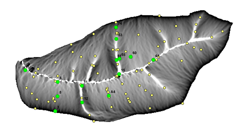
The Real-Time Soil Moisture Monitoring Network provides integrated observation of water, energy and temperature in the soils of the Shale Hills Susquehanna Critical Zone Observatory watershed. Dielectric Constant is measured at 4 depths at 2 sites. Imaginary Dielectric Constant is measured with Hydra Probes manufactured by Stevens Instruments.
Subject Keywords
Coverage
Spatial
Temporal
| Start Date: | |
|---|---|
| End Date: |
Content
ReadMe.md
SSHCZO -- Hydropedologic Properties -- Imaginary Dielectric Constant -- Shale Hills -- (2010-2011)
OVERVIEW
Description/Abstract
The Real-Time Soil Moisture Monitoring Network provides integrated observation of water, energy and temperature in the soils of the Shale Hills Susquehanna Critical Zone Observatory watershed. Dielectric Constant is measured at 4 depths at 2 sites. Imaginary Dielectric Constant is measured with Hydra Probes manufactured by Stevens Instruments.
Creator/Author
Lin, Henry
CZOs
Shale Hills
Contact
Dr. Henry Lin, Crop and Soil Science, The Pennsylvania State University, 444 Agricultural Sciences and Industries Building, University Park, PA. 814-865-6726 henry.lin@psu.edu
Subtitle
Level 1 - Quality Controlled Data
SUBJECTS
Disciplines
Soil Science / Pedology
Topics
Hydropedologic Properties
Subtopic
Imaginary Dielectric Constant
Keywords
soil|water|hydrology|hydropedology|soil science|dielectric constant
Variables
Julian Day|Decimal Time of Day|Imaginary Dielectric Constant|Imaginary Dielectric Constant|Imaginary Dielectric Constant|Imaginary Dielectric Constant
Variables ODM2
Imaginary dielectric constant
TEMPORAL
Date Start
2010-12-08
Date End
2011-02-09
SPATIAL
Field Areas
Susquehanna Shale Hills Critical Zone Observatory
Location
Shale Hills
North latitude
40.6644460592
South latitude
40.664180911799995
West longitude
-77.9056734264
East longitude
-77.9056485629

REFERENCE
Citation
The following acknowledgment should accompany any publication or citation of these data: Logistical support and/or data were provided by the NSF-supported Shale Hills Susquehanna Critical Zone Observatory.
Publications of this data
Lin, H.S., Kogelmann, W., Walker, C., and Bruns, M.A. (2006). Soil moisture patterns in a forested catchment: A hydropedological perspective. Geoderma 131:345-368. http://dx.doi.org/10.1016/j.geoderma.2005.03.013
Publications using this data
Graham, C., and Lin, H.S. (2011). Controls and Frequency of Preferential Flow Occurrence: A 175-event Analysis. Vadose Zone Journal 10:816-831 http://dx.doi.org/10.2136/vzj2010.0119
Jin, L., Andrews, D.M., Holmes, G.H., Lin, H., and Brantley, S.L. (2011). Opening the 'Black Box': Water Chemistry Reveals Hydrological Controls on Weathering in the Susquehanna Shale Hills Critical Zone Observatory . Vadose Zone Journal 10:928-942, http://dx.doi.org/10.2136/vzj2010.0133
Lin, H.S., and Zhou, X. (2008). Evidence of Subsurface Preferential Flow Using Soil Hydrologic Monitoring in the Shale Hills Catchment . European Journal of Soil Science 59:34–49. http://dx.doi.org/10.1111/j.1365-2389.2007.00988.x
Lin, H.S. (2006). Temporal stability of soil moisture spatial pattern and subsurface preferential flow pathways in the Shale Hills Catchment. Vadose Zone Journal 5:317-340. http://dx.doi.org/10.2136/vzj2005.0058
Takagi, K. and H.S. Lin. (2011). Temporal Dynamics of Soil Moisture Spatial Variability in the Shale Hills Critical Zone Observatory. Vadose Zone Journal 10:832-842, http://dx.doi.org/10.2136/vzj2010.0134
CZO ID
2607
COMMENTS
Comments
Probe Depths at each site, in cm: Site 11: 11, 24, 36, 51; Site 12: 11, 27, 48, 64
Additional Metadata
| Name | Value |
|---|---|
| czos | Shale Hills |
| czo_id | 2607 |
| citation | The following acknowledgment should accompany any publication or citation of these data: Logistical support and/or data were provided by the NSF-supported Shale Hills Susquehanna Critical Zone Observatory. |
| comments | Probe Depths at each site, in cm: Site 11: 11, 24, 36, 51; Site 12: 11, 27, 48, 64 |
| keywords | soil, water, hydrology, hydropedology, soil science, dielectric constant |
| subtitle | Level 1 - Quality Controlled Data |
| variables | Julian Day, Decimal Time of Day, Imaginary Dielectric Constant, Imaginary Dielectric Constant, Imaginary Dielectric Constant, Imaginary Dielectric Constant |
| disciplines | Soil Science / Pedology |
Related Resources
| This resource is referenced by | Lin, H.S., Kogelmann, W., Walker, C., and Bruns, M.A. (2006). Soil moisture patterns in a forested catchment: A hydropedological perspective. Geoderma 131:345-368. http://dx.doi.org/10.1016/j.geoderma.2005.03.013 |
How to Cite
This resource is shared under the Creative Commons Attribution CC BY.
http://creativecommons.org/licenses/by/4.0/

Comments
There are currently no comments
New Comment