Checking for non-preferred file/folder path names (may take a long time depending on the number of files/folders) ...
This resource contains some files/folders that have non-preferred characters in their name. Show non-conforming files/folders.
This resource contains content types with files that need to be updated to match with metadata changes. Show content type files that need updating.
| Authors: |
|
|
|---|---|---|
| Owners: |
|
This resource does not have an owner who is an active HydroShare user. Contact CUAHSI (help@cuahsi.org) for information on this resource. |
| Type: | Resource | |
| Storage: | The size of this resource is 25 bytes | |
| Created: | May 20, 2025 at 4:38 a.m. (UTC) | |
| Last updated: | Feb 04, 2026 at 9:41 p.m. (UTC) | |
| Citation: | See how to cite this resource |
| Sharing Status: | Public |
|---|---|
| Views: | 1288 |
| Downloads: | 49 |
| +1 Votes: | Be the first one to this. |
| Comments: | No comments (yet) |
Abstract
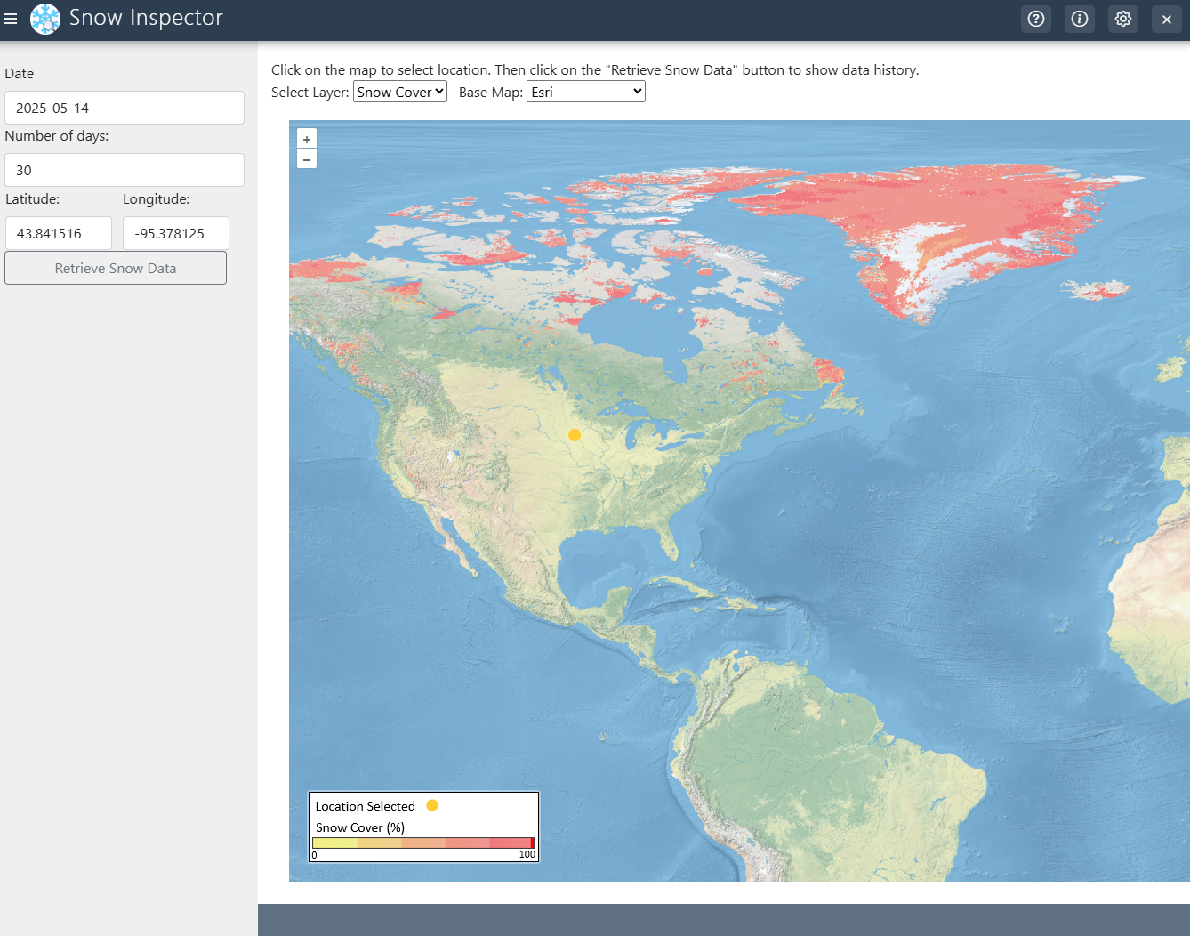
This application is designed to deliver global, interactive visualizations of critical snowpack parameters—including spatial snow cover extent, snow mass (snowpack density), and snow water equivalent (SWE)—to enhance hydrological forecasting and climate resilience. By aggregating and processing geospatial snow data from satellites, ground sensors, and model outputs, the app enables users to analyze temporal and spatial trends in snow dynamics, such as melt rates, accumulation patterns, and seasonal variability. These insights directly support flood risk mitigation, drought preparedness, and water supply planning by reducing uncertainties in predicting snowmelt-driven streamflow. The platform integrates near-real-time imagery from NASA’s Global Imagery Browse Service (GIBS), a publicly accessible repository managed by the Earth Science Data and Information System (ESDIS) with funding from NASA Headquarters. GIBS provides high-resolution snow cover maps via services like MODIS and VIIRS, which are rendered as interactive, time-lapse layers within the app.
Citing the foundational work of Kadlec et al. (2016), the app employs methodologies for extracting snow cover time series from web mapping tile services, ensuring compatibility with open-access standards. Their research demonstrates how tile-based protocols can efficiently disseminate large-scale snow datasets while minimizing server load, a principle embedded in this tool’s architecture. Users, from hydrologists to emergency managers, can overlay snow metrics with terrain or watershed boundaries, export data for hydrological models (e.g., SWAT), and correlate snowpack trends with historical flood events. Acknowledgment guidelines mandate proper attribution to NASA/ESDIS and original data providers to uphold licensing and intellectual property requirements.
Subject Keywords
Coverage
Temporal
| Start Date: | |
|---|---|
| End Date: |
Content
Additional Metadata
| Name | Value |
|---|---|
| page_url | https://tethys.ciroh.org/apps/snow-inspector/ |
| thumbnail_url | https://ciroh-portal-static-data.s3.us-east-1.amazonaws.com/f496f871-baa9-4532-941e-5a916522b132.png |
How to Cite
This resource is shared under the Creative Commons Attribution CC BY.
http://creativecommons.org/licenses/by/4.0/
Comments
There are currently no comments
New Comment